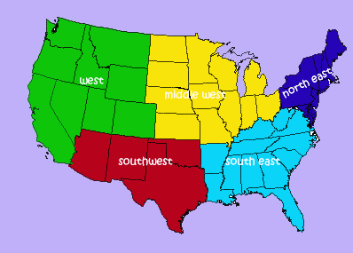
Regions of the US
Project #1636 on iSENSEProject.org
4th graders in Massachusetts study the different regions of the United States, the states within those regions, and their capitals. This project is designed to allow the students to virtually explore the various regions and the states that make up those regions.
Standards:
4.9 - Locate the states of the Midwest, Northeast, Southeast, Southwest, and West regions of the United States, in addition to the six states of New England. See Appendix H (revised) for a listing of states in each region.
4.10 - Identify the states, state capitals, and major cities in each region
4.11 - Describe the climate, major physical features, and major natural resources in each region
Guiding Questions:
Which state capital is the farthest west?
Which state capital is the farthest south?
Which state capital has the hottest average temperature in July?
HINT: Group by individual region and select "Average July Temp." for the Y axis.
Which state capital has the coldest average temperature in January?
Resources: www.weatherbase.com
| Name | Units | Type of Data |
|---|---|---|
|
Northeast - Mid Atlantic
|
|
Text
|
|
Average July Temp.
|
degrees F
|
Number
|
|
Average Jan. Temp.
|
degrees F
|
Number
|
|
Northeast - New England
|
|
Text
|
|
Southeast
|
|
Text
|
|
Midwest
|
|
Text
|
|
Southwest
|
|
Text
|
|
West
|
|
Text
|
|
Latitude
|
|
Latitude
|
|
Longitude
|
|
Longitude
|
| Northeast - Mid Atlantic | Average July Temp. | Average Jan. Temp. | Northeast - New England | Southeast | Midwest | Southwest | West | Latitude | Longitude |